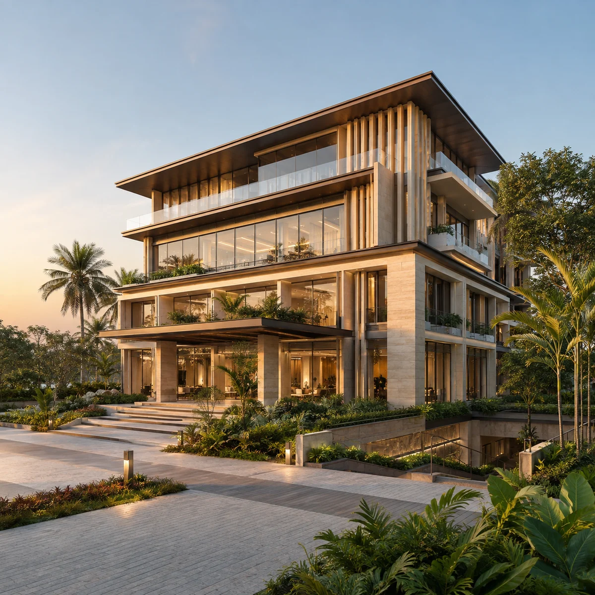
This page does two things. First, it sets out the location as the regulatory record gives it, and explains where the material circulating about this project departs from that record. Second, it gives connectivity entirely from a routed road-distance table, with no straight-line figures dressed up as drive distances.
A note on the source of every number below. The location facts come from two filings by Embassy Developments Limited: proposal SIA/KA/INFRA2/587631/2026, an environmental clearance application filed on 03/08/2026 and still Under Examination, and the earlier SIA/KA/INFRA2/571718/2026, for which a Standard Terms of Reference was granted on 04/05/2026 by SEAC Karnataka under ToR identification number TO26B3812KA5752877N and state file number SEIAA 148 CON 2026. Every distance comes from a routed OSRM table computed from the coordinate this page publishes.
The address Embassy Sadahalli files under
The signed Terms of Reference certificate prints the site's location as Navarathna Agrahara Village, Jala Hobli, Yelahanka Taluk, Bangalore – 562 157. The Common Application Form record adds the district, Bengaluru Urban, and carries sub-district code 7103. The revenue village code is 612888.
The address line this site uses is therefore:
MS Engineering College Road, Navarathna Agrahara, Jala Hobli, Yelahanka Taluk, Bengaluru 562157.
Set against what has been circulating:
| Field | Material in circulation | What this site publishes | Basis |
|---|---|---|---|
| Village | Navarathna Agrahara | Navarathna Agrahara | Signed certificate and CAF agree |
| Hobli | not stated | Jala Hobli | Signed certificate |
| Taluk | "Devanahalli" | Yelahanka Taluk | Signed certificate; CAF sub-district code 7103 |
| District | not stated | Bengaluru Urban | CAF |
| Postcode | a Bengaluru Rural postcode | 562157 | Signed certificate reads "Bangalore – 562 157" |
| Street framing | "MSEC Road, Navarathna Agrahara, Sadahalli, Devanahalli" | MS Engineering College Road, Navarathna Agrahara | Signed certificate |
One further address token appears in the circulating material and does not appear on this site: it could not be located in any gazetteer or map source we checked, so we do not publish it. An address element nobody can find is not an address element.
A spelling note, because it will come up in searches. The filings spell the revenue village Navarathna Agrahara, with an h. The working title on this site drops it, as Navaratna Agrahara. Both refer to the same village. We have kept the certificate's spelling wherever we are quoting the record and used the simpler spelling for the project's working title.
Why the taluk correction on Navaratna Agrahara matters
It would be easy to treat "Devanahalli" versus "Yelahanka Taluk" as a labelling quibble. It is not. Devanahalli is a different taluk in a different district — Bengaluru Rural. A buyer who accepts the wrong taluk inherits a chain of wrong assumptions.
- The sub-registrar's office is different. Registration, stamp duty payment and encumbrance searches happen at the office for the taluk the land actually sits in.
- The revenue records are held elsewhere. Survey sketches, mutation records and RTC extracts for a Yelahanka Taluk village are not filed with a Devanahalli office.
- Local body and civic jurisdiction differ. Which authority levies property tax, which handles khata, which is responsible for the approach road — all of that follows the taluk and district, not the marketing pin.
- Comparable-price research goes wrong. Rates published for "Devanahalli" or for the Sadahalli revenue village are for other localities. Applied to this village, they mislead in both directions.
Our reading is that the wrong framing is bleed-through from Embassy's own projects elsewhere in North Bengaluru. Embassy Developments Limited holds several K-RERA registrations in the region, and those sit at Hegganahalli and Nagamangala villages in Kundana Hobli, Devanahalli, Bengaluru Rural — genuinely Devanahalli, genuinely a different district. One of them, Embassy Greenshore, is registered by signed certificate at a different village, a different hobli, a different taluk and a different district from this parcel. Aggregators that attach the Greenshore name to this road are attaching a different project to it, and this site is not that project. The same applies to other Embassy sub-brands that circulate for this corridor without any K-RERA registration behind them.
One caution on our own reasoning, so you can check it. We do not rest the correction on the pincode. Postcode 562157 also appears on the signed certificate for an Embassy project at Nagamangala Village, Kundana Hobli, in Devanahalli taluk, Bengaluru Rural. Pincodes straddle the taluk boundary here and prove nothing on their own. The correction rests on the signed certificate's own hobli and taluk fields, which are unambiguous.
What you may fairly say about the location in ordinary language: this is the North Bengaluru airport corridor. That is how the market thinks about it and it is true. What you should not say is that it is in Devanahalli, or in the Sadahalli revenue village. Our own working title points at Sadahalli Gate on NH-44, a highway interchange 3.4 km away, and not at the village of that name.
The coordinate this site publishes, and what it is not
We publish 13.20404, 77.62470.
That figure is inferred, at medium confidence, and here is exactly how it was derived. The filings carry a KML boundary for the parcel. Its bounding box runs from latitude 13.20228 to 13.20579 and from longitude 77.62328 to 77.62611. Those extents are verified — they are the filed geometry. The coordinate we publish is the centre of that box, which is our own arithmetic, not a surveyed point.
Two honest qualifications follow from that.
The bounding box is a rectangle drawn around an irregular parcel, so the box is larger than the land and its centre is not the centroid of the site. And a centre point is not a gate. This is not a surveyed coordinate, it is not the project entrance, and we publish it to five decimals precisely because more precision than that would be a false claim.
Two other coordinates are in circulation for this project. One of them sits roughly 620 metres from the centre of the filed box and falls outside the filed geometry altogether; we discard it. The other falls inside the filed box, about 144 metres from its centre, and is consistent with our figure — but it and the Plus Code circulating alongside it appear to have been generated from the same map link, so they are one datum rather than two independent confirmations. We treated them as one.
The land itself is filed at 6.80 hectares, which is 16.80 acres, with a plot area of 68,012.5 sq m and a built-up area of 262,029.83 sq m, at a filed project cost of Rs 564 crore. The earlier filing gave the land as 6.45 hectares, or 15.94 acres, with a built-up area of 261,294.83 sq m. The later filing lists four survey numbers the earlier certificate does not, and the filed land area rises from 6.45 to 6.80 hectares. We are not going to tell you that the one caused the other — no record states a per-survey-number area, and one survey number changed from a full to a partial holding, which would work the other way.
The parcel is assembled from survey numbers 124(P), 129(P), 131(P), 132(P), 134(P), 136(P), 137(P), 138(P), 139(P), 140(P), 141(P), 142(P), 143(P), 144, 145(P), 146, 147, 148, 149(P) and 150(P) in the revenue village. Those numbers, not the pincode and not the pin, are what identifies this land.
For a sense of how intensively the parcel is to be used: dividing the filed built-up area by the filed plot area gives 262,029.83 ÷ 68,012.5 = about 3.85. Treat that as an estimate of intensity and nothing more. We do not know what the filing counts inside "built-up area" — basements and service areas are commonly included — so it should not be read as a sanctioned floor-area ratio.
MS Engineering College Road, and the distance to NH-44
The address names MS Engineering College Road, usually written MSEC Road, after the campus it runs to. The routed table puts M S Engineering College at 0.90 km by road. The road is a local corridor serving the college and the villages around it, not a state or national highway.
The site does not front NH-44. Material in circulation puts the project "approximately 4 km from NH-44", which is roughly right in magnitude but imprecise in a way that matters. The properly stated figure is about 3.4 km by road to the Sadahalli Gate interchange, which is the named access point onto the highway. Naming the interchange is the point: "4 km from NH-44" is meaningless without saying where you get on.
There is a second honesty gap worth stating plainly. The filings identify the land by survey number and boundary, not by street frontage. We can tell you the certified address line and the routed distance to the college the road is named for. We cannot tell you how many metres of frontage the parcel has onto MSEC Road, where the project's access point will be cut, or whether the approach road will be widened, because no document we hold says any of that. If a channel partner tells you the length of the frontage, ask which filing it comes from.
How to read the routed distances on this page
Every kilometre figure below is OSRM road distance on the OpenStreetMap driving profile, measured from the published coordinate. Destinations are live OpenStreetMap records. Where OSM does not carry a place, it was dropped rather than guessed, which is why some categories below are thinner than a brochure's.
Two deliberate omissions.
We publish no drive times. Not one number of minutes appears on this page. Free-flow times are a floor nobody in Bengaluru experiences, and a single peak figure is a ceiling that is materially overstated on long highway legs. A minute count on a property page is almost always somebody's best case presented as a fact. Kilometres are checkable; minutes are not.
We publish no straight-line distances as distances. The detour column in the tables below is the ratio of road distance to straight-line distance, and on this parcel it is unusually informative, so it stays visible.
That ratio produces a real finding, and it is the opposite of what most buyers expect.
| Journey type | Example | Detour ratio |
|---|---|---|
| Very short, local | M S Engineering College, 0.90 km | ×3.15 |
| Short, local | Navrathna Agrahara Lake, 0.99 km | ×1.75 |
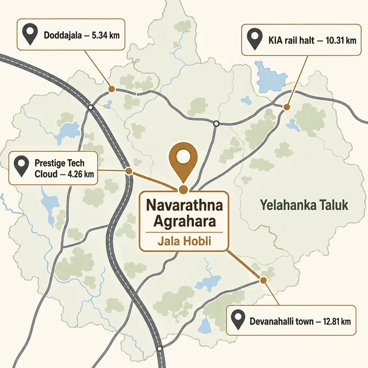
| Short, local | Prestige Tech Cloud, 4.26 km | ×1.83 |
| Medium | Kempegowda International Airport Halt, 10.31 km | ×1.83 |
| Long, highway | Kempegowda International Airport, 11.67 km | ×1.32 |
| Long, highway | Devanahalli, 12.81 km | ×1.28 |
| Long, highway | Yelahanka Junction, 15.89 km | ×1.37 |
Short local trips here carry the worst detours; the long airport run is efficient. The college is 0.29 km away in a straight line and 0.90 km by road — you drive more than three times the map distance to reach something you can see. That is the signature of a village lane network that has not yet been rationalised into a grid. Beyond about eleven kilometres, once a journey joins the highway, the ratios collapse to 1.26 to 1.4, which is close to as direct as Indian road geometry gets.
The practical reading: this location is better connected to far things than to near ones. Anything within five kilometres will take longer than the map suggests. Anything on the highway will not.
Employment within reach of Navaratna Agrahara
| Destination | Routed km | Detour |
|---|---|---|
| Prestige Tech Cloud | 4.26 | ×1.83 |
| Indian Council of Medical Research | 5.59 | ×1.56 |
| SLK Software | 6.17 | ×1.80 |
| Airport Rescue and Fire Fighting Station | 10.81 | ×1.27 |
| Hinduja Ecopolis | 11.56 | ×1.36 |
| Kempegowda International Airport | 11.67 | ×1.32 |
| Dynamatic | 13.24 | ×1.28 |
| MSME Technology Centre | 14.22 | ×1.28 |
| Boeing India Engineering and Technology Center | 14.36 | ×1.32 |
| North Gate Business Park, Phase 1 | 14.42 | ×1.43 |
| North Gate Business Park, Phase 2 | 14.42 | ×1.45 |
| Embassy Business Hub | 15.13 | ×1.41 |
| IFCI Financial City | 15.18 | ×1.80 |
| Embassy Business Hub, Philips | 15.20 | ×1.42 |
The airport is 11.67 km by road. Material in circulation understates that badly. The figure quoted in the marketing material is lower than the parcel's straight-line distance to the airport, which is 8.86 km — and no road journey can be shorter than the crow-flies distance. It is refuted on its own arithmetic, and we do not reproduce it. The routed figure is the only airport distance this site publishes.
The shape of the employment map is worth stating without decoration. There is a light cluster inside about six kilometres — a technology park, a research institute, a software campus — and then a gap, and then the substantial employment mass at eleven to fifteen kilometres, which is the airport itself and the business parks strung along the highway north and south of it. If your workplace is in that outer band, the highway legs above are direct. If it is in central or eastern Bengaluru, nothing on this table helps you and you should plan on a long commute.
One thing the table does not do is tell you the size of any of these. These are OpenStreetMap-named nodes. A name in OSM says a place exists at that point; it says nothing about headcount, occupancy or whether a campus is fully built.
Rail, and the Doddajala ambiguity
| Destination | Routed km | Detour | What it actually is |
|---|---|---|---|
| Doddajala | 5.34 | ×1.70 | See the caution below |
| Betta Halasuru | 6.92 | ×1.45 | A halt |
| Kempegowda International Airport Halt | 10.31 | ×1.83 | A halt |
| Devanahalli | 12.81 | ×1.28 | Transit node on the corridor |
| Rajanukunte | 13.28 | ×1.85 | Transit node on the corridor |
| Yelahanka Junction | 15.89 | ×1.37 | Nearest full junction with real service |
| Dodballapur | 20.18 | ×1.73 | Transit node on the corridor |
Read the word "halt" carefully. A halt on a suburban line is not the same thing as a station with meaningful passenger service. The two nearest rail nodes to this parcel, at 6.92 km and 10.31 km, are halts. The nearest full railway junction with real service is Yelahanka Junction, 15.89 km by road.
Now the point that most listings for this corridor get wrong. "Doddajala" is ambiguous and has to be disambiguated every time. There is a Doddajala railway halt, and there is a planned Doddajala metro station on the Blue Line, Phase 2B, the KR Puram to airport corridor. The 5.34 km row above is the OpenStreetMap node routed from our pin — it is the rail node, not a metro entrance.
The metro station is under construction and not operational. We do not publish an opening date for it, because we have no document that fixes one, and a date taken from a news report is not a commitment. Any material that presents metro access at this parcel as an existing amenity is describing something that does not yet carry passengers. If metro proximity is central to your decision, treat it as a proposal with an uncertain date, price the location as it stands today, and treat the station as upside if it arrives.
Schools near Navaratna Agrahara
| Destination | Routed km | Detour |
|---|---|---|
| Embassy Academy | 1.62 | ×1.69 |
| VEDIC | 2.87 | ×1.67 |
| NAFL North Urbana | 6.48 | ×1.63 |
| Gurukul School | 7.81 | ×1.76 |
| Stonehill International School | 8.56 | ×1.75 |
| Katherine Public School | 9.06 | ×1.72 |
| Sadhu Vashwani International School | 9.08 | ×1.67 |
| Harrow International School | 10.98 | ×1.33 |
| Kendriya Vidyalaya, Yelahanka AFS | 11.70 | ×1.41 |
| Vidyashilp Academy | 12.88 | ×1.44 |
| VIBGYOR High School Yelahanka | 15.89 | ×1.66 |
| Canadian International School | 15.98 | ×1.60 |
| Orchids The International School, Yelahanka | 15.98 | ×1.84 |
| Delhi Public School Bangalore North | 16.54 | ×1.68 |
| National Public School, North | 16.75 | ×1.49 |
Schools are the strongest single argument for this stretch of the corridor. Two are inside three kilometres by road, and the international-school cluster that North Bengaluru is known for sits between eight and sixteen kilometres. Note the detour ratios in the eight-to-nine kilometre band, which run from ×1.67 to ×1.76 — a nine-kilometre school run here is not a nine-kilometre school run somewhere with a grid.
Two cautions. Distance is not admission, and it is not a school bus route; whether any of these operates transport to this village is not something the routed table can tell you. And the closest entry, Embassy Academy, shares a name with the developer — we make no claim about any arrangement between the school and this project, because we hold no document about one.
Colleges, and the campus cluster on MSEC Road
| Destination | Routed km | Detour |
|---|---|---|
| M S Engineering College | 0.90 | ×3.15 |
| Akash Global College of Management and Science | 4.01 | ×1.36 |
| Vidyashilp University | 4.77 | ×1.84 |
| Sri Revanna Siddeshwara Institute of Technology | 5.85 | ×1.61 |
| Cambridge Institute of Technology North Campus | 7.32 | ×1.49 |
| Sri Venkateshwara College of Engineering | 8.59 | ×1.70 |
| IIBS Bengaluru Airport Campus | 8.74 | ×1.52 |
| Krishnadevaraya College of Dental Science | 8.91 | ×1.42 |
| Sir M Visvesvarayya Institute of Technology | 9.04 | ×1.43 |
| Amity University | 11.25 | ×1.36 |
| Manipal Academy of Higher Education, Bengaluru | 13.80 | ×1.46 |
| Nitte Meenakshi Institute of Technology | 14.16 | ×1.54 |
| REVA University | 15.39 | ×1.55 |
| Presidency University | 17.33 | ×1.66 |
This is the densest category in the table, and it explains the road's name. Higher education arrived on this corridor before housing did, which has two consequences a buyer should weigh in opposite directions: a standing rental demand from students and staff, and the traffic and land-use character that comes with a campus belt rather than a residential one.
Hospitals reachable from Navaratna Agrahara
| Destination | Routed km | Detour |
|---|---|---|
| N.R.V Hospital | 7.26 | ×1.59 |
| Lakshmi Hospital | 8.06 | ×1.57 |
| Krishnadevaraya Hospital and Research Centre | 8.90 | ×1.42 |
| Vikrant Hospital | 12.15 | ×1.42 |
| Sapthagiri Hospital | 13.07 | ×1.42 |
| Valens Hospitals | 13.19 | ×1.42 |
| CyteCare | 14.68 | ×1.52 |
| Brains Hospital | 14.68 | ×1.51 |
| Manipal Hospital North | 15.17 | ×1.38 |
| Yelahanka Government Hospital | 15.51 | ×1.29 |
| Manipal Hospital | 18.35 | ×1.72 |
This is the weakest connectivity category for this parcel, and it should be said in plain words. Nothing in the routed table is inside seven kilometres. The nearest entries at seven to nine kilometres are small local hospitals. The names most buyers would recognise as multi-speciality capability sit at thirteen to eighteen kilometres by road, and the ratios on the Manipal Hospital leg at ×1.72 tell you that leg is not a straight run.
Be careful what you infer from a name on this list. An OpenStreetMap record confirms a hospital exists at a point. It says nothing about whether it has an emergency department, an intensive care unit, a cardiac catheterisation lab or a trauma bay. If a household member has a condition that makes minutes matter, this is the category on which to do your own verification, on the ground, before committing.
Retail, and what the routed table cannot tell you
| Destination | Routed km | Detour |
|---|---|---|
| Sattva Park Cubix | 14.17 | ×1.27 |
| The Arcade | 15.04 | ×1.33 |
That is the entire mall category. Organised retail is fourteen to fifteen kilometres away, which for practical purposes means a planned weekend trip, not an errand.
For everyday needs — grocery, a chemist, a bank branch, a vegetable market — the routed table has nothing to offer, and we are not going to invent it. OpenStreetMap does not carry reliable records for small neighbourhood retail in this village, and we do not publish what we cannot route. What we can tell you honestly is the shape of the problem: a village-edge parcel on a college road, with organised retail fourteen kilometres out and no verified data on what sits between. Everyday shopping will depend on what the surrounding villages already support and on what the project's own retail provision turns out to be, and neither of those is documented in anything we hold.
This is a category to walk, not to read about. Drive MSEC Road on a weekday evening and look at what is actually open.
Lakes and open water around the parcel
| Destination | Routed km | Detour |
|---|---|---|
| Navrathna Agrahara Lake | 0.99 | ×1.75 |
| Tarabanahalli Lake | 3.99 | ×1.75 |
| Chikkajala Lake | 4.64 | ×1.42 |
| Kadiganahalli Tank | 7.85 | ×1.74 |
| Doddajala Kere | 8.00 | ×1.92 |
| Bettahalasuru Lake | 8.04 | ×1.60 |
The village lake is 0.99 km by road, 0.56 km in a straight line. This part of the corridor still has a working tank system, which is part of what makes it feel semi-rural today. One practical note: lake proximity is a drainage question as much as an amenity one, and the buffer rules around a tank affect what can be built near it. Neither is something we can assess for you from the filings.
Who else is building in Navarathna Agrahara village
This revenue village is not empty of development, and one point of confusion needs clearing up because it affects how you read comparables.
A Mahindra Lifespace project sits in the same revenue village and the same pincode. Pincode is therefore useless as a way of telling the two parcels apart. The discriminators that do work are survey numbers and promoter: Embassy's parcel is assembled from survey numbers 124 to 150, filed by Embassy Developments Limited; the Mahindra parcel is at survey numbers 7 to 12 and 92, filed by Anthurium Developers Limited, which Mahindra Lifespace Developers identified as its subsidiary in its own press release of 23 January 2025.
The filed geometries confirm the separation. The two bounding boxes are disjoint on both axes, with an east–west edge gap of about 1.07 km, a north–south gap of 57 m, and box centre to box centre of 1.47 km. There is zero overlap. They are neighbours in the same village, not the same land.
Separately, DS Max Sky Shlokam is registered with K-RERA in this revenue village, which is a useful data point for one reason: it establishes that registrable residential development in Navarathna Agrahara has already reached the registration stage. It is a different product class from anything Embassy would build here and we do not treat it as a comparable.
On Embassy's own footprint: Embassy has an established presence on this corridor, and its Embassy Springs township is marketed with an address in this same revenue village, which is a large part of why aggregators confuse the two. Springs sits roughly one to 2.4 kilometres away on the same corridor — a proximity figure, not a routed road distance, because our routed table does not carry the township as a destination. This project is not part of Embassy Springs, does not share its registrations, and should not be assumed to share its amenities or its phasing.
The approvals that govern this location
The land use question is settled in the developer's own filing. Embassy's Form-1 states that the site "has been converted from agricultural to non-agricultural i.e residential use as per the Comprehensive Development Plan (CDP) of BIAAPA" — the Bengaluru International Airport Area Planning Authority, spelled with the doubled A. BIAAPA is the plan-sanctioning authority for this belt. The environmental track is separate and sits with SEAC and SEIAA Karnataka. The two should not be conflated: a BIAAPA-conforming land use does not imply environmental clearance, and a Terms of Reference does not imply either.
No environmental clearance has been granted for this project. A Standard Terms of Reference was granted on 04/05/2026 on the earlier filing. The current environmental clearance application, filed 03/08/2026, is Under Examination. A ToR is permission to prepare and submit an assessment; it is not a clearance.
What Navaratna Agrahara asks you to accept
A location page that lists only strengths is a brochure. Here is the honest ledger for this parcel.
What is genuinely good. The airport is 11.67 km by road on an efficient highway leg. Schooling is unusually strong for a village-edge site, with two options inside three kilometres and the international cluster within sixteen. Higher education is dense enough that rental demand has an obvious source. Land use is settled under the BIAAPA plan, which removes one of the larger risks a pre-launch North Bengaluru parcel can carry. And the address, once corrected, sits in Bengaluru Urban district rather than Bengaluru Rural, which is a modest but real administrative advantage.
What you are accepting. Healthcare is thin — nothing meaningful inside seven kilometres, recognisable multi-speciality capability at thirteen to eighteen. Organised retail is fourteen kilometres out and everyday retail is undocumented. The local road network is inefficient in a measurable way, with detour ratios of ×1.6 to ×3.15 on nearly every trip under seven kilometres, so short journeys cost more than a map implies. Rail access today is halts, not stations; the nearest junction with real service is 15.89 km. And the metro station that would change the calculus is under construction, not operational, on a date we will not guess at.
What is simply unknown. The frontage and access arrangement onto MS Engineering College Road. Whether the approach road is to be widened. What everyday retail exists within a short drive. Whether school transport serves this village. None of that is in any document we hold, and we would rather leave the gaps visible than fill them with plausible sentences.
The location's character today is a college road on the airport corridor, at the point where a village is being converted into a housing belt. A parcel of 16.80 acres carrying 1,304 apartments and 48 villaments — 1,352 homes in total across 8 towers, with a standalone clubhouse building — is a significant addition to that belt. Much of what would make this an easy place to live is proposed rather than built, both on the site and around it. That is a legitimate thing to buy into at pre-launch pricing, but it should be bought into with the timeline understood rather than assumed. For buyers already comfortable with the embassy-group name, Embassy Millennium adds a local portfolio lens without skipping the practical checks around cost and daily use.
The regulatory position at Navaratna Agrahara
This project holds no K-RERA registration and no pending registration application. Embassy Developments Limited holds registrations for other projects, all of them at Hegganahalli or Nagamangala in Kundana Hobli, Devanahalli — none of them is this one.
Under Section 3 of the Real Estate (Regulation and Development) Act 2016, a project in a registrable class cannot lawfully be advertised, marketed, booked or sold until registration has been granted. Nothing on this page is an offer, a booking channel or an invitation to pay. PropNewz is an independent publisher of project information, not the developer and not a broker, and this microsite exists as an information and enquiry resource for a scheme still at the approvals stage. If anyone offers you a unit, a floor, a price or a pre-registration payment at this address today, that offer is being made ahead of the registration the law requires.
Frequently Asked Questions
Embassy Sadahalli Location — frequently asked questions
One, and it needs framing. DS Max Sky Shlokam, a K-RERA-registered project in the same revenue village, is published by its developer at Rs 7,700 per sq ft for 2 BHK and Rs 7,900 per sq ft for 3 BHK on built-up area, from Rs 92.70 lakh. That is a real developer-published rate in this village, which is rare and worth knowing. It is not a comparable. DS Max is a volume-market developer and an Embassy product would not price at that level; use it as a floor reference for the locality and nothing more. Aggregator rates labelled "Sadahalli" or "Devanahalli" are a different village in a different taluk and do not describe this land.
The closest is Embassy Academy at 1.62 km by road, followed by VEDIC at 2.87 km. Beyond those, NAFL North Urbana is 6.48 km, Gurukul School 7.81 km, Stonehill International School 8.56 km, Harrow International School 10.98 km, Vidyashilp Academy 12.88 km and Canadian International School 15.98 km. On the higher-education side, M S Engineering College — the institution the access road is named after — is 0.90 km away, Akash Global College of Management and Science 4.01 km, and Vidyashilp University 4.77 km. Read that list honestly: two schools are genuinely close, and the better-known international campuses of North Bengaluru sit between 8.56 km and 15.98 km away, each way, every school day, on a corridor with real traffic.
The nearest entries in our routed table are N.R.V Hospital at 7.26 km, Lakshmi Hospital at 8.06 km and Krishnadevaraya Hospital and Research Centre at 8.90 km. Larger and better-known facilities are further: Vikrant Hospital 12.15 km, Sapthagiri Hospital 13.07 km, CyteCare 14.68 km, Manipal Hospital North 15.17 km and Yelahanka Government Hospital 15.51 km. The honest summary is that there is no large multi-speciality hospital in the immediate neighbourhood. For routine care the seven-to-nine kilometre cluster is workable. For anything serious, plan on a 12 to 16 kilometre journey, and remember that these are road distances on a corridor where peak-hour traffic lengthens every one of these runs materially.
None of the three, and the confusion is worth untangling because aggregators attach all of these names to this road. Embassy Greenshore is a separately registered K-RERA project whose certificate places it at Hegganahalli Village, Kundana Hobli, Devanahalli, Bengaluru Rural 562110 — a different village, hobli, taluk, district and pincode, inside the Embassy Springs township. "Embassy Edge" carries no K-RERA registration at all. Embassy Springs itself sits roughly one to 2.4 kilometres away on the same corridor, and Embassy markets that township with an address on MSEC Road, Navarathna Agrahara — our parcel's own village, which is precisely why the two get merged online. This project is a separate parcel with its own filings.
There are two unrelated schemes in Navarathna Agrahara Village, and the discriminators that actually work are the survey numbers and the promoter — not the pincode, which both share.
| Item | Embassy | Mahindra |
|---|---|---|
| Promoter of record | Embassy Developments Limited | Anthurium Developers Limited |
| Survey numbers | 124–150 | 7–12 and 92 |
| Filed longitude extent | 77.62328–77.62611 | 77.63596–77.63951 |
| Filed latitude extent | 13.20228–13.20579 | 13.19907–13.20176 |
The two filed boundaries are disjoint on both axes — roughly 1.07 km of east–west edge gap, 57 m north–south, and 1.47 km between the two boundary-box centres. There is no overlap of land. Anthurium Developers Limited is a Mahindra Lifespace subsidiary, per Mahindra Lifespace's own press release of 23 January 2025.
Enquire about Embassy Sadahalli
Embassy Sadahalli is at the stage where the useful thing is information rather than a booking, because there is no lawful booking to make. Leave your details and we will tell you when the position changes — when a Karnataka RERA number is issued, when the environmental file moves, and when the developer publishes a price, a floor plate and an amenity schedule. The enquiry form asks for a name, phone number, email address and message; name and phone are required.
Send an Enquiry